Maritime Buoyage System: The Complete Guide to Safe Navigation
Sailing without reference points is a direct route to running aground. Maritime buoyage is the highway code of the seas — a structured system of buoys and lights essential for safety and orientation.
Whether you are a recreational boater or a professional mariner, mastering this signaling system is not optional — it is a matter of safety. This guide breaks down the international IALA system to help you “read” the sea, avoid hazards, and navigate with confidence, day and night.
What Is Maritime Buoyage?
Before heading offshore, it is essential to understand what the term buoyage truly encompasses and who governs these sentinels of the sea.
The official definition of maritime buoyage refers to all fixed or floating marks (buoys, beacons, towers) installed to assist navigators in determining their position or following a safe route.
Although often used interchangeably, there is a subtle distinction between buoyage and marine signaling:
- Buoyage refers specifically to physical marks close to the water (channel buoys, danger marks).
- Marine signaling is a broader term that includes major lighthouses, radio signals (AIS, GPS), and sound signals.
The primary objectives of buoyage are threefold:
- Indicating hazards – marking rocks, wrecks, or shoals hidden beneath the surface.
- Defining channels – outlining maritime “highways” to guide vessels in and out of ports.
- Providing orientation – offering visual reference points to confirm position on nautical charts.
Who Is Responsible for Maritime Buoyage?
The installation and maintenance of these aids to navigation are governed by a strict and structured regulatory framework:
- International level: The International Association of Marine Aids to Navigation and Lighthouse Authorities (IALA) harmonizes buoyage rules worldwide so that mariners can interpret marks consistently, regardless of the ocean they are crossing.
- In France: Responsibility lies with the Directorate General for Maritime Affairs, Fisheries and Aquaculture. Technical operations are carried out by the renowned Phares et Balises services, which maintain thousands of navigational aids along the French coastline.
- Local authorities: In port areas or specific inland waters, management may be delegated to port authorities or local governments, always under state supervision.
The Different Types of Maritime Buoyage
Understanding buoy meanings is the foundation of safety at sea. The buoyage system is based on a precise code of shapes and colors that must be thoroughly learned.
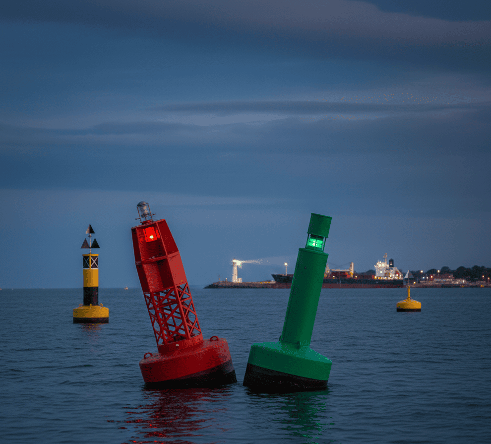
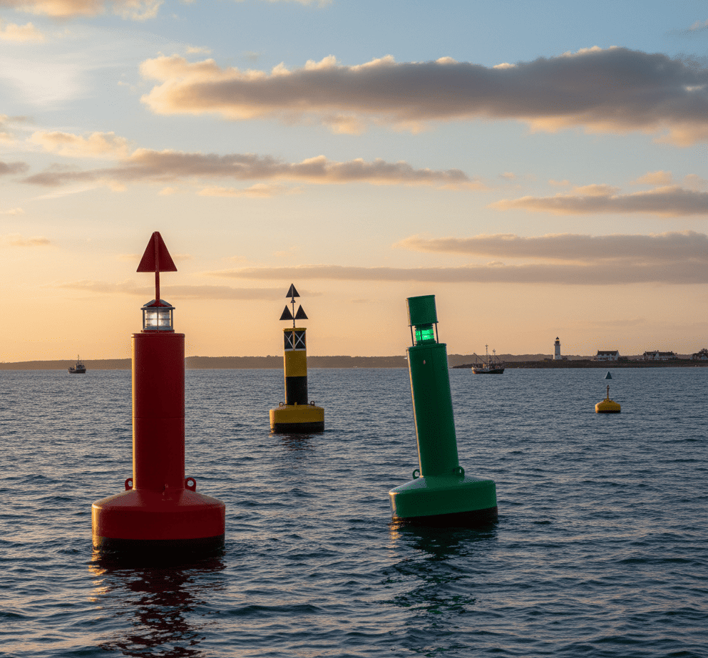
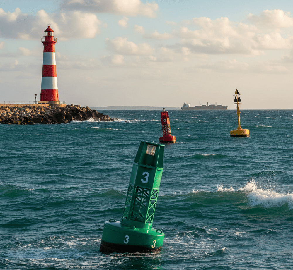
Lateral Marks: Port and Starboard Buoyage
Lateral marks define access channels to ports. They indicate the left and right limits of the navigable route.
- Port Mark: Red, with a cylindrical topmark.
- Starboard Mark: Green, with a conical topmark.
- Conventional direction: In IALA Region A (Europe), red marks are kept to port (left) and green marks to starboard (right) when entering from seaward (the “inbound” direction).
Cardinal Marks: Navigating in Relation to a Hazard
Cardinal marks indicate where safe water lies in relation to a danger (rock, wreck). They are colored yellow and black and carry two black cones as topmarks.
| Type | Position of Black Cones | Buoy Colors | Where to Pass |
| North | Two cones pointing up | Black over Yellow | Pass north of the hazard |
| South | Two cones pointing down | Yellow over Black | Pass south of the hazard |
| East | Cones pointing away (diamond shape) | Black – Yellow – Black | Pass east of the hazard |
| West | Cones pointing toward each other (hourglass) | Yellow – Black – Yellow | Pass west of the hazard |
Isolated Danger Marks
These marks are placed directly over a small, isolated hazard surrounded by navigable water.
- Appearance: Black with one or more horizontal red bands.
- Topmark: Two black spheres, one above the other.
- Action: Keep well clear, as the danger lies directly beneath or very close to the mark.
Safe Water Marks
These buoys indicate that the water around them is navigable. They often mark the beginning of a channel or the centerline of a fairway.
- Appearance: Vertical red and white stripes.
- Topmark: A single red sphere.
- Purpose: Used as landfall marks or to confirm a safe approach route.
Special Marks
These buoys do not directly indicate navigational hazards but mark specific zones or activities.
- Appearance: Entirely yellow, sometimes with an “X”-shaped topmark.
- Usage: Dredging areas, military exercise zones, submarine cables, anchorage areas, weather stations.
Safety tip: Although these marks may not indicate a rocky hazard, they often designate restricted or regulated areas that should be avoided.
The International Maritime Buoyage System (IALA)
For a French sailor to navigate safely off the coasts of Japan or Brazil, everyone must speak the same visual language. That is the crucial role of the IALA system.
Overview of the IALA System
The International Association of Marine Aids to Navigation and Lighthouse Authorities (IALA) is the organization responsible for the worldwide harmonization of navigational signals.
Before this standardization, more than thirty different buoyage systems existed around the world, creating dangerous confusion for international crews.
The goal of this global standardization is twofold:
- To standardize the meaning of colors, shapes, and light characteristics.
- To ensure that any navigator, regardless of nationality, can instantly recognize a hazard or a safe channel.
The Two IALA Regions (A and B)
Despite the harmonization effort, the world is divided into two buoyage regions: Region A and Region B.
The only significant difference between them is the reversal of lateral mark colors (port and starboard). Cardinal marks, isolated danger marks, and safe water marks are identical worldwide.
Regional Comparison
| Feature | Region A | Region B |
| Areas Covered | Europe, Africa, Australia, New Zealand, most of Asia | North & South America, Japan, Korea, Philippines |
| Port Mark | Red (Cylinder) | Green (Cylinder) |
| Starboard Mark | Green (Cone) | Red (Cone) |
Why This Matters for International Navigators ?
For a captain crossing the Atlantic toward the Caribbean or the United States, extra vigilance is required. When entering a U.S. port (Region B), the color rules for lateral marks are reversed compared to European waters.
A well-known mnemonic in Region B helps sailors remember this:
“Red Right Returning” — keep red buoys to starboard when returning from seaward.
Understanding these distinctions is essential for safe navigation during offshore passages or international vessel deliveries.
How to Read and Interpret Maritime Buoyage
Knowing how to interpret buoys relies on a systematic approach. At sea, identifying a mark is a step-by-step process — whether you are navigating under bright sunshine or in total darkness.
Daytime Identification: Visual Recognition
During daylight, three key elements allow you to identify a mark, even from a considerable distance:
- Colors
The first and most immediate indicator.- Red and green for channels
- Yellow and black for cardinal hazards
- Red and white vertical stripes for safe water
- Shapes
The buoy’s silhouette (can, cone, spar, or framework) confirms its function.
For example, in Region A, a cylindrical shape always indicates a port mark. - Topmarks
In backlighting or poor color visibility, the topmark becomes decisive.- Cylinder: Port
- Cone: Starboard
- Two black cones: Cardinal mark (orientation determines direction)
Night Navigation: The Language of Marine Lights
At night, buoy shapes and colors disappear. Only their lights guide the navigator. Each aid to navigation has a unique light signature indicated on nautical charts.
Light Colors
- Red: Port mark (Region A)
- Green: Starboard mark (Region A)
- White: Cardinal, isolated danger, or safe water marks
- Yellow: Special marks
Light Characteristics (Rhythms)
The flashing pattern defines the type of mark:
- Continuous quick flashing: North cardinal
- Group of 3 flashes: East cardinal
- Isophase or occulting: Often used for safe water marks
- Group flashes (e.g., 2 flashes): Isolated danger mark
Light Range
Displayed in nautical miles (M) on charts, this indicates the maximum visibility distance of the light. A prudent mariner always anticipates the appearance of a light on the horizon to confirm position and course.
A Sailor’s Tip
To avoid confusing cardinal marks at night, use the face of a clock:
- 3 flashes = East (3 o’clock)
- 6 flashes + 1 long flash = South (6 o’clock)
- 9 flashes = West (9 o’clock)
- Continuous quick flashing = North (12 o’clock)
The Difference Between Maritime Buoyage and Port Signaling
Once the channel has been cleared, the navigator enters a more confined environment where signaling changes in nature. Port signaling complements maritime buoyage to ensure precise maneuvering in high-traffic areas.
Shore-Based vs. Offshore Signaling
While maritime buoyage relies primarily on floating structures (buoys) or fixed offshore installations (beacons and towers), port signaling depends largely on shore-based systems.
- At sea: The objective is to avoid natural obstacles and maintain safe positioning relative to submerged hazards.
- In port: The focus shifts to traffic control. Harbor lights (often mounted on masts at the end of breakwaters or on port buildings) regulate vessel entry and departure, much like road traffic lights.
Port-Specific Rules
Entering a port is governed by strict visual codes that take precedence over standard channel buoyage:
- Traffic signals: A signal mast may display vertical combinations of red and green lights to authorize or prohibit entry (for example, during ferry departures or maintenance operations).
- Speed limits: Shore-based signs often indicate speed restrictions in the outer harbor (commonly 3 or 5 knots) to minimize wake.
Leading Lights: Absolute Precision
One of the most effective tools for entering a narrow or rock-lined harbor.
- Principle: Two lights (or daymarks) are positioned ashore, one behind the other, at different elevations.
- Interpretation: When the two marks align vertically, the vessel is on the “leading line” — the safest track into the harbor. If the lights separate horizontally, the navigator immediately knows the vessel is drifting off course and must correct heading.
This system provides far greater precision than a single buoy, as it allows immediate detection of even minor lateral deviation.
Maritime Buoyage and Safety at Sea
Buoyage is not merely decorative coastal infrastructure — it is the first line of defense against major accidents. Mastery of the system is inseparable from responsible seamanship.
Risk Prevention
Strict adherence to navigational marks serves three fundamental safety functions:
- Preventing groundings: By marking channel limits and shoals, buoyage keeps vessels in waters whose depths are verified by hydrographic authorities.
- Preventing collisions: By channeling traffic — especially in narrow passages or traffic separation schemes — marks prevent chaotic crossing patterns between vessels.
- Environmental protection: Certain special marks designate protected zones, seagrass beds, or marine reserves. Respecting these limits prevents anchor or hull damage to fragile ecosystems.
The Captain’s Responsibility
Under maritime law, the captain is the ultimate authority onboard and bears full responsibility for the chosen course. Ignoring or misinterpreting a buoy constitutes a navigational fault.
In the event of an accident, authorities systematically verify whether the skipper made proper use of available aids to navigation (buoys, charts, GPS) to ensure crew safety.
Maritime Buoyage in France
France possesses the second-largest maritime domain in the world, requiring exceptionally precise organization. Combining tradition with advanced technology, French coastal buoyage is internationally recognized.
National Organization: The Excellence of Phares et Balises
In France, buoyage management is centralized under the Directorate General for Maritime Affairs. Operational responsibilities are carried out by the Phares et Balises services (within the regional sea directorates).
These teams oversee an impressive network:
- More than 6,000 aids to navigation (fixed and floating).
- Specialized buoy tenders capable of lifting multi-ton buoys for maintenance operations.
Maintenance and Modernization: The Era of Smart Buoyage
The French network continues to modernize, integrating sustainability and cutting-edge technology:
- Solar energy: Nearly all lighted buoys are now autonomous, powered by photovoltaic panels.
- AIS (Automatic Identification System): An increasing number of buoys are equipped with AIS transmitters, allowing vessels to display them directly on radar screens or navigation tablets — even in zero visibility.
Coastal Specificities: Three Seaboards, Three Challenges
Navigators must adapt their vigilance depending on the coastline:
- The English Channel: Characterized by strong tidal currents and record tidal ranges. Here, buoyage must withstand powerful tides that can submerge or heavily strain buoys under current.
- The Atlantic Coast: Exposed to ocean swell, buoyage is particularly robust. Estuary channels (Loire, Gironde) shift frequently, requiring constant updates to lateral marks.
- The Mediterranean: With minimal tides, hazards often consist of rocky seabeds close to shore. Seasonal swimming zone markings (the yellow 300-meter buoys) are widespread during summer to separate recreational boaters from swimmers.
Conclusion
Mastering maritime buoyage is far more than a theoretical requirement — it is the cornerstone of your safety and that of your crew. Whether you encounter a cardinal mark or a lateral buoy, every signal carries a vital instruction designed to prevent accidents.
Before every departure, refresh your knowledge and ensure your charts are up to date.
Fair winds to all — and remember: at sea, vigilance begins with observation.